Walking along the icy edge of the Ukika River, I take a path through a dense evergreen forest of southern beech trees, where clusters of orange fungi—round and golf ball-sized—dot the landscape. The branches are alive with miniature worlds, covered in tiny bryophytes (mosses, liverworts, and hornworts) and draped with wispy strands of old man’s beard lichen that sway as I pass. Twisting roots and fallen logs crisscross the trail, while the fierce wind shakes the treetops, sending an eerie creaking through the air. I’m alone, but now and then, the sharp, rhythmic tapping of a Magellanic woodpecker cuts through the noise, its bright red head hidden somewhere above.
Eventually, I step out of Parque Municipal Ukika and watch as the river slices across a pebbly beach, emptying into the steel-gray Beagle Channel. This winding waterway cuts through Tierra del Fuego, connecting the Atlantic and Pacific. To my right is Villa Ukika, a small Indigenous Yahgan community; to my left, the outskirts of Puerto Williams—the southernmost city on Earth.
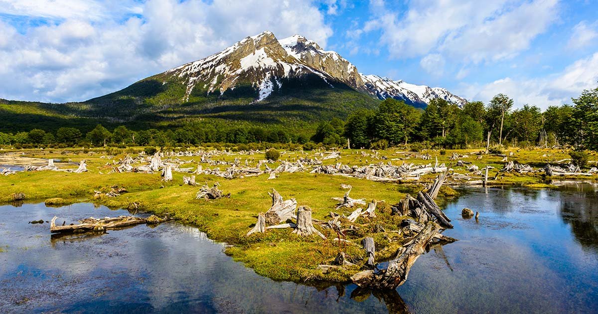
Below Patagonia, South America splinters into a maze of islands, islets, cliffs, and peninsulas, carved by winding rivers and draped in deep green forests and shimmering glaciers. This is Tierra del Fuego, the “Land of Fire.” According to Selk’nam oral tradition, the land was shaped by a young man named Táyin, who “grabbed stones and hurled them in all directions with his slingshot. Where they landed, great cracks split the earth and filled with water.”
Tierra del Fuego’s poetic name comes from the bonfires of the Selk’nam people, spotted by Portuguese explorer Ferdinand Magellan in 1520 during his attempt to sail around the world. Five centuries later, this sparsely populated region—split between Argentina and Chile—remains wild. Still, more tourists are arriving in Ushuaia, once a penal colony nicknamed the “Siberia of the South,” now Tierra del Fuego’s largest city and a gateway to Antarctic cruises.
But few venture farther south across the Beagle Channel (named after the ship that carried a young Charles Darwin on his historic voyage) to Chile’s Navarino Island, home to Puerto Williams. In 2019, Chile upgraded this 2,800-person settlement from a town to a city. It sits 1,500 miles from Santiago but just 670 miles from Antarctica.
Reaching Puerto Williams requires a plane or boat, and its remoteness is part of its charm. On my first visit, before the pandemic, I took the long way—a bus from Punta Arenas, a ferry across the stormy Strait of Magellan to Isla Grande, then south through Argentine Tierra del Fuego, ending in Ushuaia after 12 hours. The next day, I crossed the Beagle Channel by boat, passing noisy sea lion colonies sprawled over rocky islets, before reaching Puerto Navarino and catching a minibus to Puerto Williams.
This time, I choose the quicker route—a 30-minute flight from Punta Arenas with breathtaking views of snow-covered Alberto de Agostini National Park. Darwin himself marveled at this place, writing in The Voyage of the Beagle about breaching whales, wild storms, and “magnificent glaciers extending from the mountain side to the water’s edge… scarcely possible to imagine anything more beautiful than the beryl-like blue of these glaciers.”
Nestled on the Beagle Channel’s southern shore, backed by dense forests and the jagged, snowy peaks of the Dientes de Navarino range, Puerto Williams is officially Chile’s Antarctic Province capital but feels like a small town. Founded as a naval base in the 1950s in Yahgan territory, it has neat white houses for military families (half the population) and a mix of civilian homes with satellite dishes, firewood piles, and scruffy dogs.
Under a late-afternoon sun, I stroll the quiet, windblown streets, passing wooden churches, municipal buildings, a school, a few closed shops and restaurants, and guesthouses. Cows and horses graze on daisy-strewn lawns, and front doors stay unlocked—crime is practically unheard of here. On a wooden boardwalk overlooking the Beagle Channel, I watch a storm petrel circle above fishing boats hauling in giant king crab.
After dinner (those delicious crabs at a nautical-themed restaurant), I talk with Anna Baldinger from my guesthouse, Hotel Fio Fio. She moved here from Austria to teach, then fell for both a local and Tierra del Fuego itself. “Puerto Williams is like a bubble—the village at the end of the world,” she says.
Though the city is only 70 years old, Yahgan communities have lived here for millennia. The island is dense with archaeological sites—middens (ancient trash piles) and circular pits from old shelters—many visible on the drive from Puerto Navarino. Maurice Van de Maele, an anthropologist and the hotel owner, estimates Navarino may have up to 2,000 such sites.
Maurice once ran the local museum, now called Museo Territorial Yagan Usi – Martín González Calderón to honor Yahgan heritage. Outside, a massive, sun-bleached whale skeleton looms; inside, displays feature bone harpoons, intricate jewelry, and expertly made canoes. The museum also details the devastation Indigenous peoples faced during 19th- and 20th-century colonization, when missionaries, gold miners, and sheep ranchers flooded the region.
This corner of Tierra del Fuego feels timeless, but change is coming. During my visit, I see only a handful of tourists—hikers, birdwatchers, anglers, or those just seeking the “end of the world.” But Antarctic cruise ships now stop more often, disgorging hundreds of jacket-clad passengers. A new dock for bigger ships is underway, along with a large hotel and an upgraded airport.
Other projects are reshaping Tierra del Fuego. The Y-905, Chile’s southernmost road, turns to gravel east of Puerto Williams near Villa Ukika, ending at a remote navy ranch. But plans may extend it to Puerto Toro, the world’s southernmost permanent settlement, now only reachable by boat. The new Cape Horn Sub-Antarctic Centre, a futuristic research hub with a wind turbine, now crowns a hill east of town.
Yet as I hike west from Puerto Williams, worries about overdevelopment fade. The trail up 2,000-foot Cerro Bandera (“Flag Hill”)—the first leg of the epic 33-mile Dientes de Navarino trek—is empty. The beech forest thins as I climb, the trees growing stunted and bent, as if bowing, until only sub-polar tundra remains.
At the top, a Chilean flag whips in the wind. The rocky ground is studded with hardy cushion plants and emerald hummocks, streaked with snow. To the north, the Beagle Channel glitters; to the south, the Dientes de Navarino peaks stab the sky. With no other hikers in sight, the wind howls, and the cold bites deep.
Remembering this is just a false summit, I add another layer and push on, following cairns for 40 minutes to a ridge with even more staggering views—a glacial lake encircled by snow-capped peaks. My hands are numb, sleet pelts my face, but I can’t help grinning, recalling Anna’s words: “When you reach Cerro Bandera’s top, no one’s ahead of you. The rest of the world feels far away.”